Temescal Creek Research & Restoration
**Click here to download a slideshow of images from Temescal Creek
** **Click here to download a map of our creek survey area (general) or detailed map 1 (Magnolia to Weirick Road), detailed map 2 (Weirick Road to Horsethief Canyon), and detailed map 3 (Horsethief Canyon to Nichols Road)
**Click here to read the results of walking all 19 miles of the creek Inland Empire Waterkeeper
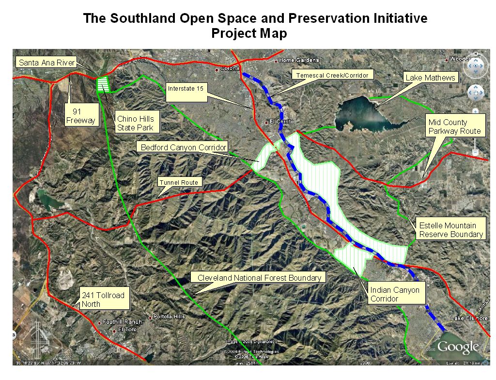
 Temescal Creek flows from the south at Lake Elsinore to the Santa Ana River in Corona near the I-15/SR-91 interchange. It lies within the valley between the Cleveland National Forest (Santa Ana Mountains) and the foothills of the Gavilan Plateau. Sections of the creek flow year-round and provide an essential north-south wildlife and open space corridor. In addition, it is an important east-west stopover between the Santa Ana's, the Plateau and the San Jacinto mountains beyond. We see this creek as an immense opportunity to improve the Temescal Valley community, both environmentally and socially. The valley is under immense pressure to develop homes and businesses that could, if not properly planned, sever any remaining open space linkages and block appealing views. Poor planning and unchecked-growth could also destroy what natural beauty is left in the creek landscape, as well as any potential aesthetic value for future generations to come.
The grant will support:
- GIS mapping
- trash removal (volunteers needed!)
- locating illegal dumping locations
- locating pockets of native and non-native plants locating potential recreational locations
- freeway signage"Santa Ana River Watershed: Keep it Clean!" at the watershed entrance on the northbound I-15.
- locating illicit discharges and
- working with local agencies and organizations toward a long-term goal of recreational sites (pocket parks) and perhaps eventually a trail.
This work is generously funded in part by Union Bank of California and the Cornell Douglas Foundation.
Advocacy
The grant includes getting community support against the Irvine-Corona Expressway tunnel and the Mid-County Parkway.
The Irvine-Corona Expressway tunnel would provide an extension from Cajalco Road at the I-15 through 12 miles of mountain to Irvine near the SR-241/SR-133 interchange. Current construction estimates are at 15 years and $10 billion, for a road that will not provide any noticeable relief for future traffic congestion - is that how you want your tax dollars spent in this recession?Project supporters have stated that this project could be a "beta test" for new tunneling techniques that would cross 4 dormant earthquake faults. The Cleveland National Forest would be criss-crossed with access roads and facilities - not to mention the 15 years of construction trucks and debris working 24 hours a day, 7 days a week. This is not what we want in our National Forest watershed for a project that will not help relieve traffic.
The Mid-County Parkway is a 32-mile, 6-lane freeway proposal from the SR-79 in Perris to the I-15 at Cajalco Road that would blaze a trail through the Gavilan Hills Plateau and the Lake Mathews community. It would bisect, cross and otherwise impact the Estelle Mountain Ecological Reserve, the El Sobrante Landfill Wildlife Conservation Area, and the Harford Springs County Regional Park, which are home to many threatened and endangered species.This watershed of Lake Mathews (a drinking water reservoir), Temescal Creek, Lake Elsinore, Canyon Lake and the San Jacinto River is one of the last vestiges of wildlands in southwest Riverside County, and should NOT be opened up for development with the introduction of a freeway.We support expansion of the SR-74 to the south, and expanding Cajalco Road to a 4-lane expressway.
Do you like this page?